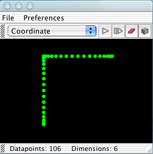
Coordinate Projection: This is perhaps the simplest possible projection technique. If one has a list of datapoints with 40 components each, coordinate projection to two-dimensions simply ignores all but two of these components, which are then used to display the data in two-space.
Background: A Cartesian coordinate system for an n dimensional Euclidean space consists of n mutually perpendicular coordinate axes meeting at the origin.The location of a point in space is specified by orthogonally projecting the point on each of the axes. This gives an n-tuple of real numbers. Selecting two components from the n-tuple gives the orthogonal projection of the point to the plane spanned by the corresponding axes. This is known as coordinate projection. In HiSee users can select which two components are used and view the object from several view points. The program can also automatically select the two most variant dimensions to project along.

Principal Component Analysis (PCA): PCA builds on coordinate projection by making use of the "principal axes" of the dataset. The principal axes of an object are the directions in space about which the object is most balanced or evenly spaced. PCA selects the two principal axes along which the dataset is the most spread out and projects the data onto these two axes.
Background: If an object could rotate freely in the high dimensional space then it would rotate about one of its principal axes. The principal axes are always mutually perpendicular to each other. Therefore a new Cartesian coordinate system can be constructed for the high dimensional space by choosing the coordinate axes to be parallel to the principal axes of the data set. By orthogonally projecting each point in the data set to the new coordinate axes we get a new n-tuple for specifying their location. The variance ( i.e. the square of the standard deviation) of the data set is computed along each of the new coordinate axes. The axis with the largest variance becomes the horizontal axis of the display. The axis with the second largest variance becomes the vertical axis of the display.
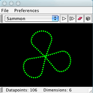
Sammon map: The Sammon map is an iterative technique for making interpoint distances in the low-dimensional projection as close as possible to the interpoint distances in the high-dimensional object. Two points close together in the high-dimensional space should appear close together in the projection, while two points far apart in the high dimensional space should appear far apart in the projection.
Background: Ideally when we project from a high dimensional space to a low dimensional space the image would be geometrically congruent to the original figure. This is called an isometric projection. Unfortunately it is rarely possible to isometrically project objects down into lower dimensional spaces but we can at least limit the amount of distortion that occurs. Congruence between two geometric objects means that corresponding inter-point distances are equal. Instead of trying to achieve equality between corresponding inter-point distances we can minimize the difference between corresponding inter-point distances. This is one goal of the Sammon mapping algorithm. When we can't achieve congruence we would at least like the projected image to be topologically the same as the original figure but often this is not possible either. A second goal of the Sammon mapping algorithm is to preserve the topology as best as possible by giving greater emphasize to smaller inter-point distances. The Sammon mapping algorithm has the advantage that whenever it is possible to isometrically project an object into a lower dimensional space it will be isometrically projected into the lower dimensional space. But whenever an object cannot be projected down isometrically the Sammon map projects it down to reduce the distortion in inter-point distances and to limit the change in the topology of the object.
